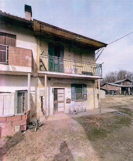
Rural building in Garlasco (PV)
Garlasco (PV)
Rural building in Garlasco (PV), Cascina Venturina n. 6
Right: full ownership
Complex of buildings with different purposes with attached areas for courtyard use and land plots for agricultural use.
Referring to the description provided by the expert appraiser Geom. Marco Ferri in the appraisal report mentioned below, the real estate subject to foreclosure consists of:
1 - Share of 1/1 of the full ownership of a portion of a former residential building accessible from a courtyard in co-ownership with third parties, arranged over two floors distributed as follows: on the ground floor a square-shaped room and a bathroom, then with a lower level a small cellar, on the first floor, reachable by an internal staircase with a single ramp, a master bedroom with a balcony and another room. All rooms are uninhabitable, in poor maintenance condition, requiring heavy renovation and refurbishment of the systems.
2 - Share of 1/1 of the full ownership of Rural Building A, a rural-type building on two floors consisting of three rooms on the ground floor used as a former stable with a small milking room and a portico wing; on the first floor, with direct access from the outside via an iron staircase, two rooms used as a former laboratory for cheese production. Completing the portion of the building are two structures also with direct access from the outside via a ladder, constituting a barn and a storage room located above the milking room; there is also a portico wing on the east front of the ground floor and uncovered areas on the east side and the west front. The entire property is in poor condition, lacking primary technological systems and requiring extraordinary maintenance.
3 - Share of 1/1 of the full ownership of Rural Building B, another rural-type building of one floor used as a storage room with an attached small plot on the south side. This building is also in poor condition and lacks functioning systems.
4 - Share of ½ (one half) of the full ownership of the courtyard area in front of the buildings and constituting the access road to them, now mapped as 1498 of CF, corresponding to map 1498 Urban Entity of sqm. 255, resulting from the suppression of the original map 832 of CT of sqm. 255. It is noted that this area is registered in the land registry with category A/3 and erroneously registered in the land registry pro rata to the executed debtor as "property for the area". From the mortgage inspections, it emerges, on the contrary, that the executed debtor owns the share of ½ of the full ownership of this property.
5 - Share of ½ (one half) of the full ownership of a plot of agricultural land
6 - Share of 1/1 of the full ownership of a plot of agricultural land treated as fallow.
 Italiano
 English
 Français
 Español
 Euskara
 Català
 Deutsch
 Nederlands
 Português
 Shqiptare
 Български
 Čeština
 Ελληνικά
 Hrvatski
 Magyar
 Македонски
 Polski
 Română
 Српски
 Slovenský
 Slovenščina
 Türkçe
 Русский
 Dansk
Dansk Suomalainen
 Íslenskur
 Norsk
Norsk Svenska
 Lombard
 Marchigiano
 Pugliese
 Romano
 Siciliano
 Toscano
 Veneto


